| ||||||||||
 

Dr. Ronald P. Rogers CHIROPRACTOR Support for your body's natural healing capabilities 270-384-5554 Click here for details 


Columbia Gas Dept. GAS LEAK or GAS SMELL Contact Numbers 24 hrs/ 365 days 270-384-2006 or 9-1-1 Call before you dig 
Visit ColumbiaMagazine's Directory of Churches Addresses, times, phone numbers and more for churches in Adair County Find Great Stuff in ColumbiaMagazine's Classified Ads Antiques, Help Wanted, Autos, Real Estate, Legal Notices, More... 


|
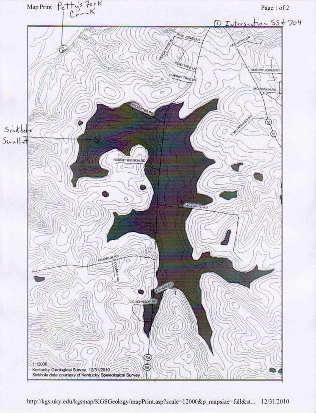
Kentucky Color - Adair County's Largest Sinkhole Permanent flowing springs in the sinkhole come together to form Sinking Branch, once an underground, then, downstream, an above ground stream near the rock quarry. Writer introduces most of us to geologic term, 'swallet,' the word for the lowest point in a sinkhole. Click on headline for full story plus map The next earlier Kentucky Color: Beauty and The Beast By Billy Joe Fudge, Retired District Forester Kentucky Division of Forestry When you turn onto Hwy 704 from South 55 you immediately descend into Adair County's largest sinkhole. As you travel from this point South on KY 704 you are traveling in this sinkhole and sinkhole plain until you reach Loy's Cemetery Road. For those who aren't familiar with sinkholes, they can best be described as depressions that are completely landlocked with all the steams and rainwater drainage running or sinking underground. The highlighted area on the accompanying map represents the area that would be best described as the collapsed area of the sinkhole and is about one and a half square miles. This area has permanent-flowing springs which come together to form Sinking Branch. These springs and water courses were once underground and dissolved or eroded the surrounding limestone causing the collapse. Sinking Branch crosses under 704 near the rock quarry entrance on its way north and then west to the sinkhole swallet. A swallet is the lowest point in a sinkhole. Swallets can be either open or closed. Several examples of both open swallet and closed swallet sinkholes can be seen in this area of KY 704 and South KY 55 and all around Columbia. There are probably more than a hundred people who live inside this sinkhole and the surrounding sinkhole plain. A sinkhole plain would be the surrounding countryside above the "collapsed area" but still in the sinkhole watershed area. This sinkhole and sinkhole plain would probably be more than three square miles. Also, the second largest Adair County Sinkhole is on the other side of town on North 61. Dixie Cash and Carry is setting in midst of that sinkhole and sinkhole plain. This story was posted on 2011-01-02 04:47:52
Printable: this page is now automatically formatted for printing.
Have comments or corrections for this story? Use our contact form and let us know.
More articles from topic Kentucky Color by Billy Joe Fudge:
Kentucky Color: Green Beast, though pretty, devours urban forest Kentucky Color: Petty's Fork Bobcat Kentucky Color: A Special Place To Live, December 2, 2010 Kentucky Color: Fogged up on a frost Kentucky Color: First Frost Flowers Nov. 28, 2010 Kentucky Color: Tears of Joy moment Kentucky Color - Bradford Pear Kentucky Color: I, We Kentucky Color in Poetry: AMIDST the TREES Kentucky Color - IncomPEARable View even more articles in topic Kentucky Color by Billy Joe Fudge |
 

115 Jamestown St. Columbia, KY. 270-384-2496 


 Provided by the Adair Co Fiscal Court and the Adair Co. Emergency Mgt. Agency 


|
||||||||
|
| ||||||||||
|
Quick Links to Popular Features
Looking for a story or picture? Try our Photo Archive or our Stories Archive for all the information that's appeared on ColumbiaMagazine.com. | ||||||||||
|
Contact us: Columbia Magazine and columbiamagazine.com are published by Linda Waggener and Pen Waggener, PO Box 906, Columbia, KY 42728. Please use our contact page, or send questions about technical issues with this site to webmaster@columbiamagazine.com. All logos and trademarks used on this site are property of their respective owners. All comments remain the property and responsibility of their posters, all articles and photos remain the property of their creators, and all the rest is copyright 1995-Present by Columbia Magazine. Privacy policy: use of this site requires no sharing of information. Voluntarily shared information may be published and made available to the public on this site and/or stored electronically. Anonymous submissions will be subject to additional verification. Cookies are not required to use our site. However, if you have cookies enabled in your web browser, some of our advertisers may use cookies for interest-based advertising across multiple domains. For more information about third-party advertising, visit the NAI web privacy site.
| ||||||||||