Travel: Cathedral Valley Loop trail
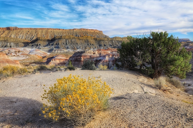
2022-11-27 - Capitol Reef National Park, Utah - Photo By Robert Ellis, Robert Ellis Woodworking
Robert writes, "The Grand Finale for our Capitol Reef Park visit...Cathedral Valley Loop trail. I mentioned this trail in my opening remarks about this park. I knew about this place before our visit, but was also aware it's not gonna be doable in a two wheel drive rental car...and yet here's an image from the trail. I put the notion of experiencing this place behind me, but as we were leaving Capitol Reef National Park we suddenly stumble upon a sign for this loop. For whatever reason at the time it didn't occur to me that this WAS the trail I wrote off as not gonna be able see...and...not until after driving for a couple miles on this dirt road, cresting the hill, taking some pics and getting back on the highway did it occur to me we got to experience it, albeit for only a couple miles.
Check this off the bucket list. What a beautiful place!
It is around a 57 mile loop, off-road trail. Part of the time you're in the National Park, and other times you leave it. Both entrances let you experience the bentonite clay formations you see in this photo. A quick search of images of bentonite hills on the internet returns lots of out-of-this-world drone pics from above the formations.
We just got a sampling, but this was my favorite place and image I took while visiting our last Park in Utah." Comments | Permalink
2022-11-27 - Capitol Reef National Park, Utah - Photo By Robert Ellis, Robert Ellis Woodworking
Robert writes, "The Grand Finale for our Capitol Reef Park visit...Cathedral Valley Loop trail. I mentioned this trail in my opening remarks about this park. I knew about this place before our visit, but was also aware it's not gonna be doable in a two wheel drive rental car...and yet here's an image from the trail. I put the notion of experiencing this place behind me, but as we were leaving Capitol Reef National Park we suddenly stumble upon a sign for this loop. For whatever reason at the time it didn't occur to me that this WAS the trail I wrote off as not gonna be able see...and...not until after driving for a couple miles on this dirt road, cresting the hill, taking some pics and getting back on the highway did it occur to me we got to experience it, albeit for only a couple miles.
Check this off the bucket list. What a beautiful place!
It is around a 57 mile loop, off-road trail. Part of the time you're in the National Park, and other times you leave it. Both entrances let you experience the bentonite clay formations you see in this photo. A quick search of images of bentonite hills on the internet returns lots of out-of-this-world drone pics from above the formations.
We just got a sampling, but this was my favorite place and image I took while visiting our last Park in Utah." Comments | Permalink
Scenic Kentucky: The climb to Cloud Splitter

2022-11-26 - Red River Gorge - Photo by Graham Waggener
Cloud Splitter is a summit in Red River Gorge that can be reached from the Sheltowee Trace Trail, near the Bison Way trailhead, that offers stunning views and challenging terrain, and plenty of chances to test your claustrophobia on the way. Comments | Permalink
2022-11-26 - Red River Gorge - Photo by Graham Waggener
Cloud Splitter is a summit in Red River Gorge that can be reached from the Sheltowee Trace Trail, near the Bison Way trailhead, that offers stunning views and challenging terrain, and plenty of chances to test your claustrophobia on the way. Comments | Permalink
Travel: Slot Canyon graffiti from 1911

2022-11-26 - Capitol Reef National Park, Utah - Photo by Robert Ellis, Robert Ellis Woodworking
Robert writes, "One of the things to look for in this slot canyon is carved, early pioneer signatures on the rock facing. Directly behind me, is the opposite wall with lots of early signatures. It is monitored by a park service camera...along with a hefty fine if you decide to add your own name to the wall. It is often missed by hikers. But this one intrigued me the most, cause I was scratching my head how they pulled this off..the names were approximately 50 feet off the ground.
As I'm writing this I just noticed the last name Gifford...then there's the Gifford house on the Park property. I haven't researched whether or not that name and the Gifford House have a connection.
More on the Gifford House here: https://www.nps.gov/care/learn/historyculture/giffordhomestead.htm" Comments | Permalink
2022-11-26 - Capitol Reef National Park, Utah - Photo by Robert Ellis, Robert Ellis Woodworking
Robert writes, "One of the things to look for in this slot canyon is carved, early pioneer signatures on the rock facing. Directly behind me, is the opposite wall with lots of early signatures. It is monitored by a park service camera...along with a hefty fine if you decide to add your own name to the wall. It is often missed by hikers. But this one intrigued me the most, cause I was scratching my head how they pulled this off..the names were approximately 50 feet off the ground.
As I'm writing this I just noticed the last name Gifford...then there's the Gifford house on the Park property. I haven't researched whether or not that name and the Gifford House have a connection.
More on the Gifford House here: https://www.nps.gov/care/learn/historyculture/giffordhomestead.htm" Comments | Permalink
Older Photos