| ||||||||||
 

Dr. Ronald P. Rogers CHIROPRACTOR Support for your body's natural healing capabilities 270-384-5554 Click here for details 


Columbia Gas Dept. GAS LEAK or GAS SMELL Contact Numbers 24 hrs/ 365 days 270-384-2006 or 9-1-1 Call before you dig 
Visit ColumbiaMagazine's Directory of Churches Addresses, times, phone numbers and more for churches in Adair County Find Great Stuff in ColumbiaMagazine's Classified Ads Antiques, Help Wanted, Autos, Real Estate, Legal Notices, More... 


|
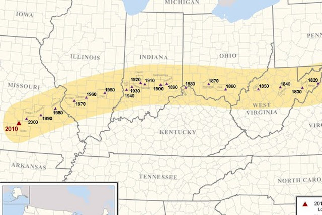
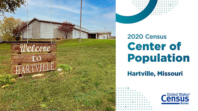
Center of US population to be announced Nov 16 The center of population is the place where an imaginary, flat, weightless and rigid map of the United States would balance perfectly if everyone weighed the same... On Tuesday, November 16, 2021, look for the U.S. Census Bureau to announce where the U.S. center of population was in last year's 2020 census. This is a way to summarize population shifts every decade. The colonial town of Chestertown, Maryland, near the Chesapeake Bay was once a major port for the trade of tobacco and enslaved people and was the center of population in the new United States in 1790 when the first census was taken. About 3.9 million people lived in the 13 original colonies along the Atlantic coast. In the 230 years since, the nation grew and expanded, and the center of the U.S. population marched steadily westward -- through Ohio, Indiana, and then Illinois. In recent decades, it's tilted to the Southwest as people moved to the Sun Belt and immigrated from the southern border. "It's amazing how the population just took huge leaps, starting off with about 3 million people and then, all of a sudden, tens of millions of people," said Sharon Tosi Lacey, the Census Bureau's chief historian. "Immigration has played a huge part in that." This month, the U.S. Census Bureau will announce the center of population based on the 2020 Census count of everyone who lived in the United States on April 1, 2020. Since 1980, that center has been in various locations in Missouri. In 2010, the center was near Plato, a small town about 75 miles northeast of Springfield. The center of population is the place where an imaginary, flat, weightless and rigid map of the United States would balance perfectly if everyone weighed the same. The point is officially marked with a survey monument by the National Oceanic and Atmospheric Administration's (NOAA) National Geodetic Survey (NGS), the U.S. government authoritative source for precise latitude, longitude and elevation measurements. Since 1990, the Census Bureau and NGS have placed the center of population monument in a publicly accessible location near the actual center of population. Knowing the center of population helps geographers, demographers and others quantify how fast and in what direction Americans are moving. How Is the Center of Population Calculated? The Census Bureau starts by figuring out the center of population for each of the more than 8 million census blocks in the nation. Every person is given the same weight. "It's not their weight in pounds," said Lee Wentela, chief of the Address and Spatial Analysis Branch in the Geography Division. "Each person has the same weight of one. A block might have 100 people, so that weight would be 100. A more-populated block, like one with 2,000 people, has a bigger influence on the location of the center of population, especially if that population increase is far away from the existing center of population." African Americans were counted as one person in determining the population center in 1790, even though African Americans in slavery were counted as three-fifths of a person for apportionment purposes. "All American Indians were not included in the calculation until the early 20th century because the center of population is based on the total enumerated population of the United States and territories. Tribal lands were considered independent nations and therefore anyone living there was not counted towards this total," Lacey said. Westward Ho! One of the most fascinating implications of knowing where the center of population is that it helps us track the country's expansion decade by decade, through key events in the nation's history from wars to economic upheaval. For example, just before the U.S. revolution against British rule, the colonial population started to spill through the Cumberland Gap in the Appalachian Mountains after Daniel Boone and his men widened the trail, originally created by migrating buffalo and long used by local Indian tribes, to accommodate wagons in 1775. More than 300,000 people poured west through the Gap over the next 35 years, igniting the nation's western expansion. Grooves in the rock from the wheels of thousands of Conestoga covered wagons can still be seen at the Gap, near Knoxville, Tennessee. As pioneers pushed through the mountains from the East and down the Ohio River from the North, the center of population jumped 99 miles by 1810 to Loudoun County, Virginia, west of Washington, D.C. At this point in U.S. history, the edge of the American frontier was the Mississippi River -- St. Louis, to be exact. From there, pioneers journeyed on the trails west to California, Utah, and Oregon. From the early 1830s until the mid-to-late 1860s, nearly 400,000 people moved in a quest for new opportunities in the West -- bringing the center of population along with them. The Gold Rush to California (1848-1855) fed the westward push, too. More than 300,000 people chased rumors that gold flowed in the rivers of California. Some found it; most didn't. The center of population leapt 103 miles in just one decade from 1850 to 1860 -- the largest single jump in distance in all the censuses taken so far. In 1860, the center was in the Midwest, in Pike County, Ohio -- 457 miles west from where it began. In 1869, the Transcontinental Railroad connected East to West and made it easier and safer to head west. Civil War and Migration While this massive westward exodus was underway, the Civil War erupted. Although it caused the largest number of deaths in U.S. history up to that point (an estimated 750,000 died, about 2.5% of the population), the war did not slow the nation's population growth or the movement of the center of population, according to Lacey. Why? For one, casualties from the war came from states that were predominantly in the East. The five states that lost the most people in the Civil War were New York, Virginia, North Carolina, Ohio and Illinois. According to the University of Virginia, Virginia was projected to gain 229,000 people between 1860 and 1870 but added only 71,000 due to losses from the war. Despite that, the steady stream of settlers moving west continued and the center of population jumped another 54 miles between 1860 and 1870. Twenty years later in 1889, President Grover Cleveland signed the Indian Appropriation Bill, which opened almost 1.9 million acres of "Unassigned Lands" in western Oklahoma to settlers, a large number of which were freed settlers supporting the effort to make Oklahoma a black state under the possibility of a black governor. This area, which had been part of the land set aside under the Indian Removal Act of 1830, had been ceded by the Creek and Seminole tribes after the Civil War and had not been settled by any other tribes. On the first day of land speculation, April 22, 1889, 60,000 settlers rushed in to claim one of the 160 acre plots. "The Land Rush pushed the center westward even more," said Lacey. Over three decades from 1860 to 1890, the U.S. population pushed to the end of the country's natural boundary, the Pacific Ocean, and the center of population moved a total of 189 miles. The Census Bureau declared the "end of the frontier" in 1890, as every county in the lower 48 states had at least two people per square mile, said Lacey. "It's interesting because we just didn't have any place, physically, to go farther west so we started to fill in the middle parts of the country," she said. "The contiguous 48 were what they are now." Then Came Ellis Island After decades of relentless movement westward, the population center abruptly stalled in the late 1800s and early 1900s because of the growth of industrial cities in the Northeast and Midwest, fueled by immigration. The westward movement of the center was slowed by the eastward tug caused by substantial population growth in the East. Ellis Island, the immigrant inspection station in the harbor of New York City, had opened. From 1892 until it closed in 1954, more than 12 million immigrants from Europe entered the country through this point. This influx of people significantly slowed the overall westward movement of the center of population. In fact, the three smallest jumps in the center of population occurred while Ellis Island was in operation. The smallest was from 1910 to 1920 (just 13 miles), followed by 1930-1940 (17 miles) and 1890-1900 (18 miles). Then Came Great Depression, War The Great Depression hit at the end of the Roaring Twenties, a time of economic prosperity and mass consumerism that redefined arts and culture. Then, World War II. Once again, the center of population stalled. But when the war ended in 1945, as soldiers returned home and people were on the move again, the nation's cities began transforming. "After the war, we had the GI Bill and VA home loans and that caused internal migration," said Lacey. "You had guys who had worked on farms go to college and move to the cities and you had the beginning of suburbs." This was accompanied by a postwar boom in California, plus the advent of air conditioning, which now made states such as Arizona and New Mexico more appealing and fueled the westward shift. All those new families in all those new houses in all those new suburbs would lead to a baby boom of more than 73 million, creating one of the largest generations in U.S. history. At the same time, the United States was desperate for farm workers and low-cost laborers. The U.S. government struck a deal with Mexico to create the bracero program, encouraging Mexicans to come across the border for work. More than 5 million laborers came here under this program until it ended in 1964. These immigrants from Mexico settled in places like Texas, New Mexico and Arizona. That's why in the 1960 Census, the center of population began to veer toward the Southwest. Internal migration also fueled the southward movement, as U.S. companies moved to take advantage of lower labor costs and cheaper housing in the Sun Belt, defined as states in the Old South like North Carolina, South Carolina, Georgia, and Florida, and those across the Southwest, like Texas and Arizona. Between 1950 and 2000, the Sun Belt's population jumped from 28% of the U.S. population to 40%. Between 1970 and 1990, the South's population grew by 36% and the West's grew by 51% -- both substantially higher than other regions. A Tiny Pull Back East? The current trend of southwestern movement seems likely to hold. Based on the 2020 Census, 62% of the entire U.S. population is in the Sun Belt. Losses in the North and Northeast have been driving growth in the South and West, a trend likely to continue. For every decennial census between 1950 and 2010, the percentage growth of the Desert Southwest (southwestern Texas, New Mexico, Arizona, southern Nevada and southeastern California) was at least twice as great as for the entire country. As migration to the South and Southwest continues, the center of population is expected to continue the same trajectory. With the rise of remote work during the COVID-19 pandemic and the movement of some people out of large cities and to smaller towns and cities, there may be some changes in the westward push over the coming decades, said Lacey. "Between 2020 and 2030 will be some interesting times," she said. "For the first time, people will be able to search for more affordable housing without having to be tied to a particular city or state for their jobs. Who knows how that will affect the center of population." The Census Bureau will announce the center of population November 16, 2021. Follow their announcements at http://www.census.gov/about/contact-us.html This story was posted on 2021-11-12 11:13:04
Printable: this page is now automatically formatted for printing.
Have comments or corrections for this story? Use our contact form and let us know.
More articles from topic News:
Increasing clouds today, windy, high 59F 7-County Area Courts for Fri 12 Nov 2021 Recent accidents highlight need for hunting safety COVID-19 News Brief & Vaccination Update 11/10/2021 Rain today, high 69F, snow possible by Friday night Adair Co. Cattlemen's Association meeting, Mon 15 Nov Gov. Beshear, Lt. Gov. Coleman host booster clinic at Capitol 2022 KDA internship application period now open KY General Fund and Road Fund receipts for October 2021 COVID-19 News Brief & Vaccination Update 11/09/2021 View even more articles in topic News |
 

115 Jamestown St. Columbia, KY. 270-384-2496 


 Provided by the Adair Co Fiscal Court and the Adair Co. Emergency Mgt. Agency 


|
||||||||
|
| ||||||||||
|
Quick Links to Popular Features
Looking for a story or picture? Try our Photo Archive or our Stories Archive for all the information that's appeared on ColumbiaMagazine.com. | ||||||||||
|
Contact us: Columbia Magazine and columbiamagazine.com are published by Linda Waggener and Pen Waggener, PO Box 906, Columbia, KY 42728. Please use our contact page, or send questions about technical issues with this site to webmaster@columbiamagazine.com. All logos and trademarks used on this site are property of their respective owners. All comments remain the property and responsibility of their posters, all articles and photos remain the property of their creators, and all the rest is copyright 1995-Present by Columbia Magazine. Privacy policy: use of this site requires no sharing of information. Voluntarily shared information may be published and made available to the public on this site and/or stored electronically. Anonymous submissions will be subject to additional verification. Cookies are not required to use our site. However, if you have cookies enabled in your web browser, some of our advertisers may use cookies for interest-based advertising across multiple domains. For more information about third-party advertising, visit the NAI web privacy site.
| ||||||||||