| |||||||||||
 

Dr. Ronald P. Rogers CHIROPRACTOR Support for your body's natural healing capabilities 270-384-5554 Click here for details 


Columbia Gas Dept. GAS LEAK or GAS SMELL Contact Numbers 24 hrs/ 365 days 270-384-2006 or 9-1-1 Call before you dig 
Visit ColumbiaMagazine's Directory of Churches Addresses, times, phone numbers and more for churches in Adair County Find Great Stuff in ColumbiaMagazine's Classified Ads Antiques, Help Wanted, Autos, Real Estate, Legal Notices, More... 


|
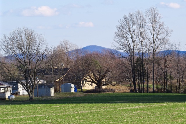
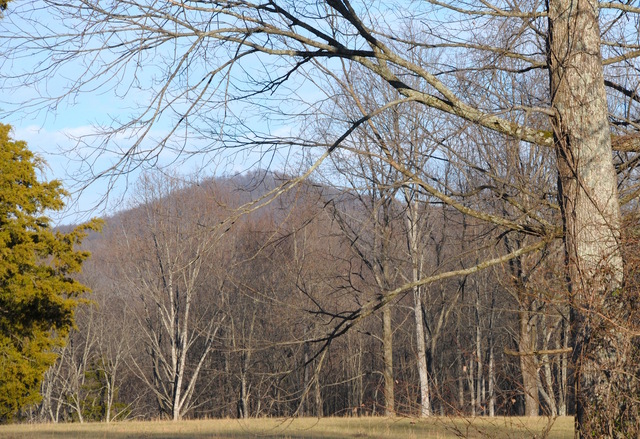
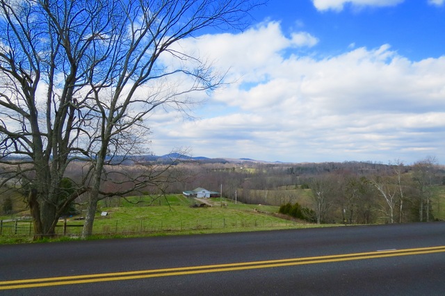
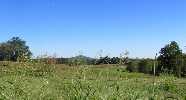
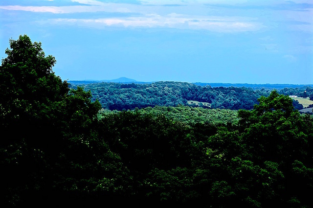
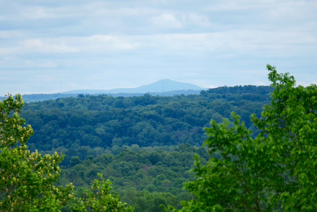
April 14, 1978 Around Adair with Ed Waggener The article below first appeared in the April 14, 1978, edition of the Daily Statesman. Topics included a trip to Metcalfe County in Michael Campbell's aeroplane, and a trip to Pulaski County in E.P. Waggener's Willys Jeep, to visit what Dad always referred to as "Daddy's Mountain". Scroll to the end of the article for some of the many photos he posted of the Knob over the years. --Pen By Ed Waggener The flame thrower is remembered I saw my old neighbor, Michael Campbell, the other day, and he said, "I remember your Daddy's flame thrower." I hadn't made mention of Mike in the story I wrote recently about Daddy and honeysuckle, but it is the truth that Michael was always ready to participate in Daddy's plans. You see, Michael is the kind of person who isn't a daredevil; he doesn't really tempt Fate. But he does aggravate it every once in a while. He calculates odds, and if the percentages look at least possible, he'll try it. I remember one time, maybe a decade ago, when Mike and I went up in his areoplane to take pictures of Edmonton. His plane was a two-seated affair, and I sat in front. On the way back, as we were passing over the hilltops around Weed, I asked Mike where he would land if we were forced down. It was before the toll road was built, and Mike looked around at pointedy hill after pointedy hill. At first he said, "Oh, we wouldn't have any trouble." But I insisted on knowing exactly where. He said, "Well, right here, there isn't any place." That was scarcy, because on the way over, Mike had told me that the little indicator sticking up above the cowl told us how much fuel we had. And at that point, the thing was almost sucked inside the plane. He saw what I was looking at--what was worrying me--and he said, "Oh, you're looking at that fuel indicator. It doesn't really work. It has a metal float and it's supposed to have a wooden one. We've still got 45 minutes of fuel left. Don't worry." I could see us crashed up on the hill behind Guy Firquin's store, where I had always wanted to have my funeral pyre built, like in Beowulf, but I had meant for that to be 120 years off. Besides, if it were to have happened then, there wouldn't have been time for spectators to arrive, and the spectacle would have been for naught. I didn't complain. But I guess I prayed. And we landed at LuDot and privately I promised myself never to fly again, with anybody, without a parachute. Daddy would do that Daddy would often go right to the edge on taking chances, and he had the same uncanny luck Michael Campbell has. In fact, they did things alike, in a lot of ways. He had a favorite view I remember that whenever we would retrace Columbia, Route 2, Daddy's second rural mail route, he liked to go by Guy Firquin's store at Weed. It has always been one of my favorite places, after Daddy first showed it to me. There were beautiful old catalpa trees behind the store, and the scene to the east seemed endless. Daddy's favorite vista in the world, including Highview, High Bridge, and the view of Hospital Hill was the view from Guy Firquin's store. You could see everywhere from the top of that hill. I had always hoped that they would build a state park at the site, but instead, the Cumberland Parkway passed through and knocked the top of the hill down. Daddy had a favorite thing to point out from there. He liked to show us where the Big Knob in Pulaski County near Nancy could be seen on the outer rim of visibility. At first, many wouldn't believe that the hill was really that far away, but on a clear day it was easy to spot, and detailed study convinced the sceptics. I always called the Knob near Nancy "Daddy's Mountain," because that is one of the things he really loved. By air, it is around 50 miles from Weed to Knob. It seemed, then, that it was twice as far by old Highway 80. Daddy wanted to climb that mountain Daddy always wanted to climb that mountain. He got the chance in around 1950 when he bought a Willys Jeep with four-wheel drive. He fixed it up for all-weather driving, and it had a quite unique appearance. He had installed an old 38 Chevrolet roof on it, added sheet-metal side paneling, and, with the extension bed he added as an aid to carrying the mail, that gray Jeep was like no other vehicle in America. It was very functional, cozy and warm, despite its lack of beauty. Daddy would use the four-wheel drive off-road almost a quarter-century before the term "four-wheeler" was coined. I remember that one Sunday he took Mike and me and I believe Ralph, over to Nancy with the express purpose of climbing that Knob. It was quite a drive around Daddy's Mountain to find the starting point. When we finally found a farmer who could tell us how to go up it, I got a little apprehensive, Michael did not. The farmer said, "Yeah, there's an old road up the back side of that hill. It hasn't been used in years. The last fellow who went up it took a team and wagon and they fell off the road. It took a terrible time to get them out. I begged Daddy not to go, but he was too close to his goal. I rode with him a little way up the mountain, but I will admit that I don't like those kinds of heights. I always thought the Jessamine County stretch of old US 27 above Camp Nelson and the Kentucky River was the most frightening experience in the world, worse than a den of Cobras. And that little Pulaski County hillside road was just as bad, to me. Daddy wouldn't give in to his sons' pleading to halt the expedition, but he did halt long enough to leave Ralph and me on the side of the hill, while Daddy, Michael, and the farmer went to the top. It seemed an eternity to us while they were gone. We both thought that was the last we'd see of any of them. I never asked Michael or Daddy what they did at the peak. They may have planted an American flag or simply wrote in the dirt, "We were here." I was relieved when they finally came down, by and by. And the trip was an accomplishment. Daddy was happy and talked to himself a lot on the way back to Columbia. He talked some to Michael, but not to Ralph and me. Still, he smiled a lot on the way back, and he whistled all the next week when he went about his work. Looking back, I think that despite the fact that his sons chickened out, I guess he had a right to be happy. It's not every day that a man gets the chance to scale his mountain. This story was posted on 2020-05-24 15:04:27
Printable: this page is now automatically formatted for printing.
Have comments or corrections for this story? Use our contact form and let us know.
More articles from topic Around Adair with Ed Waggener:
September 29, 1977 Around Adair with Ed Waggener November 2, 1977 Around Adair with Ed Waggener May 5, 1978 Around Adair with Ed Waggener January 18, 1978 Around Adair with Ed Waggener February 9, 1978 Around Adair with Ed Waggener May 1978 Around Adair by Ed Waggener April 29, 1978 Around Adair with Ed Waggener February 2, 1978 Around Adair with Ed Waggener March 14, 1978 Around Adair with Ed Waggener April 18, 1978 Around Adair with Ed Waggener View even more articles in topic Around Adair with Ed Waggener |
 

115 Jamestown St. Columbia, KY. 270-384-2496 


 Provided by the Adair Co Fiscal Court and the Adair Co. Emergency Mgt. Agency 


|
|||||||||
|
| |||||||||||
|
Quick Links to Popular Features
Looking for a story or picture? Try our Photo Archive or our Stories Archive for all the information that's appeared on ColumbiaMagazine.com. | |||||||||||
|
Contact us: Columbia Magazine and columbiamagazine.com are published by Linda Waggener and Pen Waggener, PO Box 906, Columbia, KY 42728. Please use our contact page, or send questions about technical issues with this site to webmaster@columbiamagazine.com. All logos and trademarks used on this site are property of their respective owners. All comments remain the property and responsibility of their posters, all articles and photos remain the property of their creators, and all the rest is copyright 1995-Present by Columbia Magazine. Privacy policy: use of this site requires no sharing of information. Voluntarily shared information may be published and made available to the public on this site and/or stored electronically. Anonymous submissions will be subject to additional verification. Cookies are not required to use our site. However, if you have cookies enabled in your web browser, some of our advertisers may use cookies for interest-based advertising across multiple domains. For more information about third-party advertising, visit the NAI web privacy site.
| |||||||||||