| ||||||||||
 

Dr. Ronald P. Rogers CHIROPRACTOR Support for your body's natural healing capabilities 270-384-5554 Click here for details 


Columbia Gas Dept. GAS LEAK or GAS SMELL Contact Numbers 24 hrs/ 365 days 270-384-2006 or 9-1-1 Call before you dig 
Visit ColumbiaMagazine's Directory of Churches Addresses, times, phone numbers and more for churches in Adair County Find Great Stuff in ColumbiaMagazine's Classified Ads Antiques, Help Wanted, Autos, Real Estate, Legal Notices, More... 


|
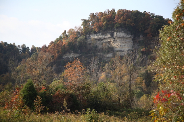
KY Afield Outdoors: Explore WMAs over the holidays By Lee McClellan Frankfort, KY - The Christmas holiday provides most of us some much-needed days off and time with family and friends, but sometimes, it is nice to escape from all of the food and festivities and stretch your legs. For those who need to relax and get away for a bit, Kentucky's wildlife management areas (WMAs) offer a place to go wander. "We have 89 public wildlife management areas, covering 525,000 acres of Kentucky," said Keith Wethington, geographic information systems program coordinator for the Kentucky Department of Fish and Wildlife Resources. With the leaves off the trees, this is a favorite time of year for hunters to explore areas for the following season. However, Wildlife Management Areas also offer overlooked opportunities for nature viewing, hiking and fishing. Visitors should be aware of Kentucky's free deer season for youth Dec. 28-29, and plan accordingly. Some recommended areas to explore this winter include:
Visitors can also download the "Explorer by ArcGIS" app to their phone before visiting any WMA. "The mobile app is great for directions and knowing where you are located on the WMA," Wethington said. "In terms of property boundaries, signs on the ground are the law and they may conflict with the mobile app. If in doubt about whether a particular spot is public or if a boundary line is accurate, inquire first with the local WMA office." Instructions on how to download the mobile app are available via the "maps" tab on the Kentucky Fish and Wildlife website. Use the website to check hunting regulations and seasons at each WMA. Unique landscapes like these await a visit over the holidays. Check the Kentucky Fish and Wildlife website at fw.ky.gov and go exploring. Author Lee McClellan is a nationally award-winning associate editor for Kentucky Afield magazine, the official publication of the Kentucky Department of Fish and Wildlife Resources. He is a life-long hunter and angler, with a passion for smallmouth bass fishing. This story was posted on 2019-12-19 13:16:02
Printable: this page is now automatically formatted for printing.
Have comments or corrections for this story? Use our contact form and let us know.
More articles from topic Ky Afield Outdoors:
Amendments to wildlife regulations proposed Record harvest for modern gun deer season KY Afield: Flooding will hamper access on management areas KY Afield Video: KDFWR Trapping Wild Pigs in Kentucky KY Afield Outdoors: Waterfowl season looks promising KY Afield Video: November 9th, 2019 Full Show KDFW debuts new crime fighting app Modern Gun Season for Deer opens statewide Nov. 9 Defend against Chronic Wasting Disease this fall Waterfowl quota hunts at Rowan, Franklin hatcheries View even more articles in topic Ky Afield Outdoors |
 

115 Jamestown St. Columbia, KY. 270-384-2496 


 Provided by the Adair Co Fiscal Court and the Adair Co. Emergency Mgt. Agency 


|
||||||||
|
| ||||||||||
|
Quick Links to Popular Features
Looking for a story or picture? Try our Photo Archive or our Stories Archive for all the information that's appeared on ColumbiaMagazine.com. | ||||||||||
|
Contact us: Columbia Magazine and columbiamagazine.com are published by Linda Waggener and Pen Waggener, PO Box 906, Columbia, KY 42728. Please use our contact page, or send questions about technical issues with this site to webmaster@columbiamagazine.com. All logos and trademarks used on this site are property of their respective owners. All comments remain the property and responsibility of their posters, all articles and photos remain the property of their creators, and all the rest is copyright 1995-Present by Columbia Magazine. Privacy policy: use of this site requires no sharing of information. Voluntarily shared information may be published and made available to the public on this site and/or stored electronically. Anonymous submissions will be subject to additional verification. Cookies are not required to use our site. However, if you have cookies enabled in your web browser, some of our advertisers may use cookies for interest-based advertising across multiple domains. For more information about third-party advertising, visit the NAI web privacy site.
| ||||||||||